The massive mountain wave cloud that kept Denver and much of the Front Range gray and chilly on Monday has dissolved. Therefore Tuesday will be a much brighter and warmer day with highs in the 60s and 70s east of the foothills.
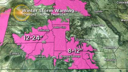
Then a storm in southern California will head straight for southern Colorado Tuesday night into Wednesday morning. Since the storm will track across the southern region of the state, the San Juan Mountains will see the highest snow amounts with 1 to 2 feet!
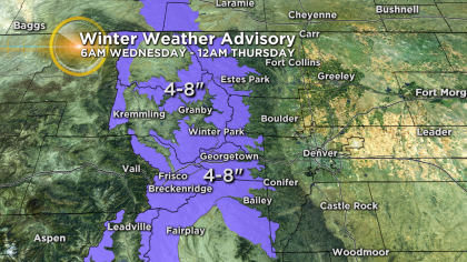
Mountain areas farther north including along the I-70 corridor will generally see 8-12 inches west of Vail Pass and 4-8 inches east of Vail Pass.

Meanwhile the Denver, Boulder, and Fort Collins areas will see rain Wednesday afternoon followed by a possible switch to light snow between 5 p.m. and 7 p.m. If the snow materializes in the metro area, it shouldn’t last long and accumulation is not expected.
Sunny and chilly weather will then settle in for Thursday with highs in the lower 40s which is near normal for the middle of January. Friday will bring highs in the lower 50s followed by lower 40s again for the weekend.